Kigali has been the economic, cultural, and transport hub of Rwanda. The city became Rwanda’s capital in 1962 when independence was gained. The city is located on the Rugwana River in the nation’s geographical centre. The settlement began as a small colonial outpost and functioned as a trade centre during the German colonial administration (after 1895). It was chartered as a city in 1907, becoming a regional centre during the Belgian colonial period of 1919–1962. When Rwanda gained independence in 1962 Kigali was selected as capital city, due mainly to its central location.
Kigali was one location of the Rwandan genocide, in 1994, and of fierce fighting between the army (mostly Hutu) and the Tutsi dominated Rwanda Patriotic Front. Following, the government made efforts to bring the people together. Rwanda faces multitude and numerous difficulties. Today Kigali is safer, cleaner, and more competitive; a modern city with expanding opportunity.
The name “Kigali” comprises the Bantu prefix “ki” and Rwanda “gali” meaning “broad.” The city takes its name from Mount Kigali.
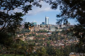
The city is built in hilly country, sprawling across about four ridges and the valleys in between, on the Ruganwa River. The tops of the ridges have an average elevation of 5,246 feet (1,600 metres) while the valleys are around 4,270 feet (1,300 metres). The city is almost ringed by higher hills, the highest of which is Mount Kigali, with an elevation of 6,075 feet (1,850 metres) above sea level.
Because of the high altitude, Kigali has a pleasant tropical highland climate. Temperatures range from 68°F (20°C) to 71°F (21.6°C) year round. There are four seasons: Long rains from mid-March to mid-May, short rains from mid-October to mid-December; a long dry period from mid-May to mid-October; and a short dry season from mid-December to mid-March. Average annual precipitation is 35 inches (900mm).
The city centre is located on one of the city’s four ridges, with the main government area on another. There is a Muslim quarter, to the northeast is a squatters’ settlement, and southeast is an industrial area. The larger houses and office buildings tend to be on the tops of the ridges, while the poorer people live in the valleys.